Outer Space Pictures
0 Directory Indexe(s), 1 Image(s)
Back to the Previous Index
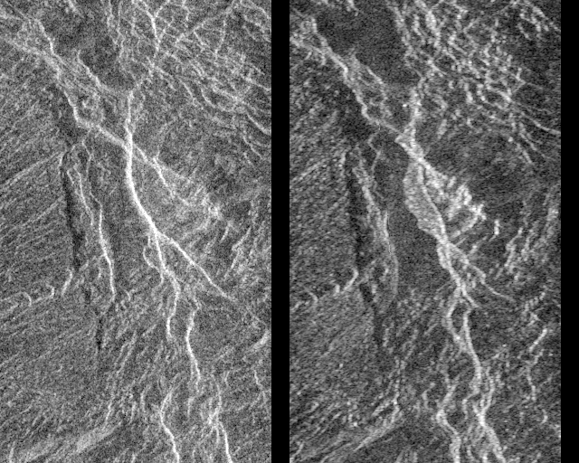
MAGELLAN IMAGE CHANGE.GIF

PUBLIC INFORMATION OFFICE
JET PROPULSION LABORATORY
CALIFORNIA INSTITUTE OF TECHNOLOGY
NATIONAL AERONAUTICS AND SPACE ADMINISTRATION
PASADENA, CALIFORNIA 91109. TELEPHONE (818) 354-5011

PHOTO CAPTION                                     Magellan
                                                  P-38975 MGN69
                                                  August 30, 1991

Landslides on Venus!  The image on the left was taken in late
November of 1990 during Magellan's first trip around Venus.  The
image on the right was taken July 23, as the Magellan spacecraft
passed over the region for the second time.  Each image is 24
kilometers (14.4 miles) across and 38 kilometers (23 miles) long,
and is centered at 2 degrees south latitude and 74 degrees east
longitude.  This pair of Magellan images shows a region in
Aphrodite Terra, within a steeply sloping valley that is cut by
many fractures.  In the center of the image on the right, a
bright, flow-like area can be seen extending to the west (left)
of a bright fracture.  The bright, rough area has appeared and
the fracture has changed position in the 8 months since the first
image was made.  A "Venusquake" may have occurred, producing a
new scarp and causing a landslide (the bright area) to form.
This is the first evidence of active tectonics occurring on other
planets in the solar system.  Resolution of the Magellan data is
120 meters (400 feet).