Outer Space Pictures
0 Directory Indexe(s), 1 Image(s)
Back to the Previous Index
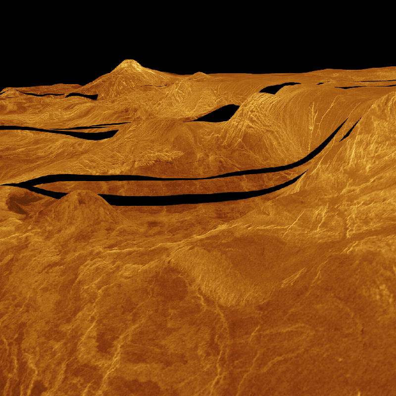
MAGELLAN IMAGE PERSPECT.GIF

JET PROPULSION LABORATORY
CALIFORNIA INSTITUTE OF TECHNOLOGY
NATIONAL AERONAUTICS AND SPACE ADMINISTRATION
PASADENA, CALIF. 91109

PHOTO CAPTION                                MAGELLAN
                                             P-37431
                                             1/3/91


Perspective view of the southern boundary of Lakshmi Planum, Ishtar Terra,
Venus.

     The southern scarp and basin province of western Ishtar Terra in the
northern hemisphere of Venus is portrayed in this three-dimensional perspective
view of Magellan radar image data.  Western Ishtar Terra is an Australia-sized
highland terrain that is a major focus of Magellan investigations.  The
highland is centered on a 2.5-to 4-kilometer-high (1.5 -to 2.5- miles-high)
plateau, Lakshmi Planum, which can be seen in the distance and to the right.
Along this part of the Planum, the surface of the high plateau drops
precipitously into the bounding lowlands, with slopes that exceed 5 percent
over 50 kilometers (30 miles).  The numerous fractures and valleys located on
and adjacent to the steep outer slope of the plateau are clues to the formation
of this unusually abrupt topographic drop.  Along other parts of the boundary
of Lakshmi are mountain ranges that rise as much as 6 kilometers (3.5 miles)
above the plateau surface to over 11,000 meters (35,000 feet) above the mean
elevation of the surface of Venus. One of these mountain ranges, Danu Montes,
rises over 1.5 kilometers (1.0 mile) above the plateau and can be seen in the
upper center of the image.

     Images such as this one show the relationship of geological features to
topography and yield a valuable new perception of the radar data.  For example,
the small dome-shaped high (center left) is a volcano that is not apparent in
the normal map-view display of Magellan images.  Only when combined with
topography in this fashion is the nature of the feature clearly evident.  These
perspective views also display fractures of the surface in their actual
topographic setting.  Understanding the relationship of topography to these
fractures, which express the stresses and motions in the outer layers of the
planet, helps geologists and geophysicists to formulate and test models for the
formation of western Ishtar. The results of these studies will add to our
understanding of the interior forces that shape the surface of Venus.


SPACELINK NOTE:
This is a ***COLOR*** image showing a synthetic perspective view of the edge of
Ishtar Terra, where the high plain of Lakshmi Planum falls off very sharply
into the lowlands.  It was generated using a large computer to "drape" the
Magellan image mosaic over the pre-existing altimetry data from Pioneer Venus
Orbiter and the Soviet Venera missions and then "view" the resulting model from
the side.  The colors used are intended to be similar to what was actually seen
on the surface by the Soviet landers at their specific local sites - Magellan's
radar does not actually provide color data.